


The Other Side of the Creek: Before El Palo Alto Stood Alone

Editor’s note: “The Other Side of the Creek” is a series designed to capture the life and spirit just beyond San Francisquito Creek — the shared landmark separating Menlo Park from the communities to the south.
From the Menlo Park side of San Francisquito Creek, El Palo Alto (pictured just behind the fence) looks singular today — one deeply furrowed coast redwood rising from the narrow strip beside the railroad. Yet a nineteenth-century photograph and several drawings show a different landmark. Two great redwood columns rise close together beside the railroad’s then single track, their crowns spreading into a broad, uneven silhouette.
The landmark’s Spanish name is commonly rendered here as “the tall tree.” It ultimately gave Palo Alto its name. By the time Palo Alto incorporated in 1894, only one of the paired redwoods documented beside the railroad remained. Later accounts called the landmark one tree with two trunks; the 1776 field notes instead suggest two redwoods growing almost together.
Two Trunks, or Two Trees?
Modern accounts usually say that El Palo Alto once had two trunks. An eighteenth-century witness used different language. Field notes quoted in Jeff Watt’s research say that when the 1776 Anza expedition reached the landmark, the party saw “not a single tree but two trees very close together.” Pedro Font’s expanded diary separately called it “the very tall redwood” and estimated it at about 50 varas high and 5½ varas around—roughly 138 feet tall by one common conversion. Juan Bautista de Anza’s official diary gave a different height, 56½ varas, while agreeing on the circumference. Even the expedition’s measurements were estimates, but the reported field-note description of two close trees is unusually clear.
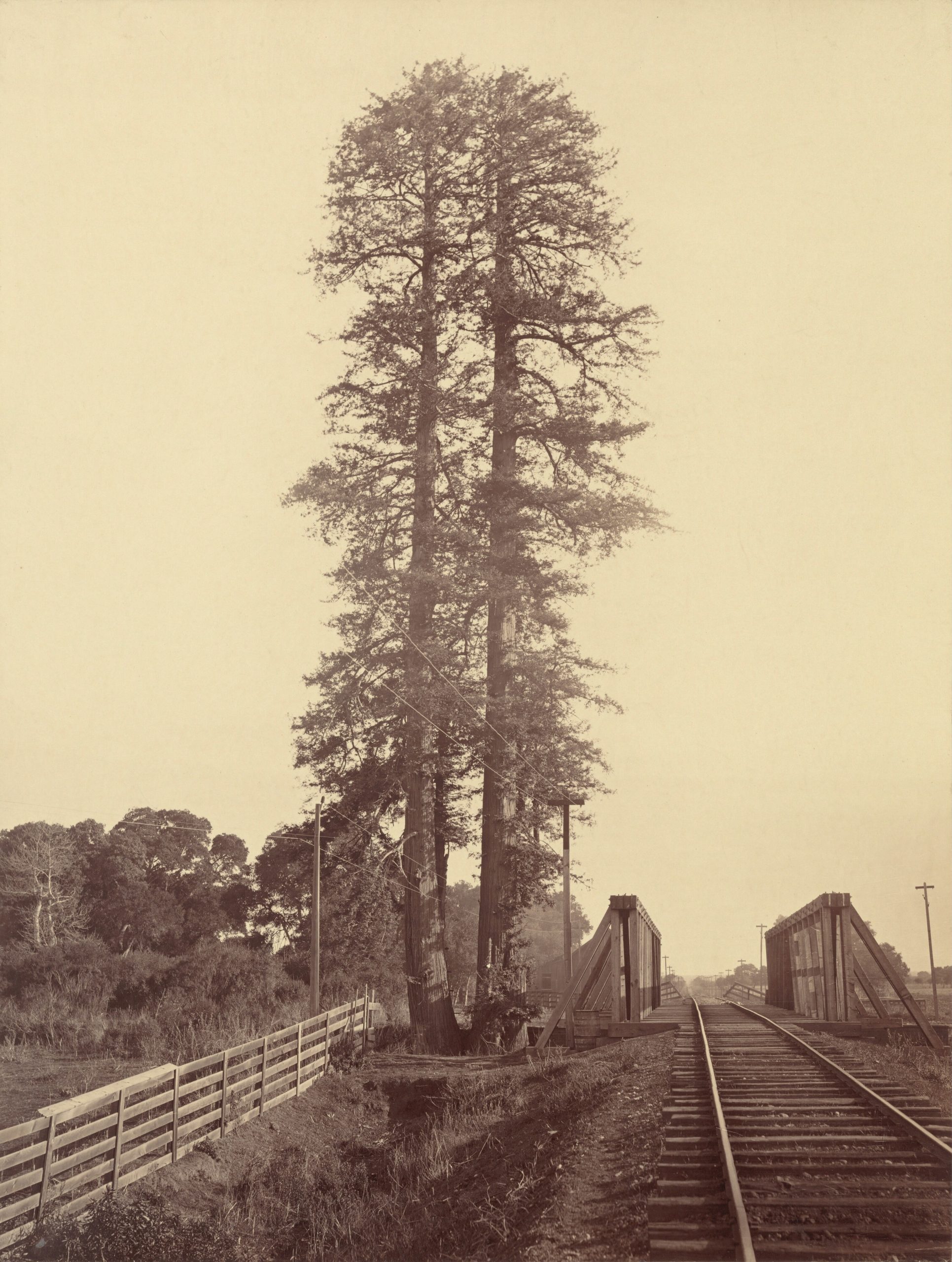 Photographs cannot determine whether the columns were genetically distinct trees, clonal stems or fused neighbors. None of the historical sources cited here settles the botanical relationship between them. “Twin trunks” remains useful shorthand for the landmark’s appearance; “two neighboring trees” is closer to the field notes. The field notes record its double form in 1776; nineteenth-century images show it again in the early railroad era.
In an 1870 publication, Edward Vischer offered a third possibility, calling the landmark “twins, once a trio.” In a Bay Nature interview, caretaker Jim Johnson pointed to an ax-scarred stump attached to the survivor as a possible remnant of a third tree or stem. Vischer did not explain his caption, and neither source establishes that three full-height redwoods stood in 1776.
The Railroad Photograph
Railroad construction began at San Francisquito Creek in 1861. Regular service from San Francisco reached Mayfield in October 1863, and the line was completed to San Jose in 1864. Watkins photographed the paired redwoods after rail service began on the single-track line. That sequence rules out one suggestion repeated in older local summaries: the companion redwood was not removed when the first railroad was built. Both redwoods were still standing beside the completed line.
The date attached to the Watkins photograph is less secure than the image itself. The National Gallery of Art currently dates its albumen print to about 1877. A version in the San José Public Library collection is cataloged as 1870, and another view of the pair is cataloged as circa 1875 . These institutional catalog dates disagree and do not securely date the exposure. The image proves that both redwoods survived into the railroad era. It cannot, by itself, establish the year in which one fell.
The Storm of 1875
Published accounts varied. An 1882 notice said the companion had fallen “some years ago.” A 1900 article assigned the winter of 1879, and later local histories favored dates in the mid-1880s. Local researcher Jeff Watt found stronger contemporaneous evidence pointing to 1875.
The clearest contemporary report appeared in the November 20, 1875 issue of the San Mateo Times. According to Watt’s reproduction of the notice, the paper reported that a large redwood beside San Francisquito Creek had fallen during a recent severe rainstorm, in which six inches of rain was reported. It called the tree one of two giant redwoods growing near each other. The notice gives a publication date, not the precise day of the fall, but it places the event shortly before November 20. Watt presented his broader research in a 2024 Palo Alto Historical Association talk; the clipping appears in his later Tall Tree follow-up .
A published 1877 illustration of the Stanford farm appears to show one distant redwood. The 1875 San Mateo Times notice did not use the later civic name El Palo Alto, but its description — one of two giant redwoods beside San Francisquito Creek — matches the location and the visual sequence.
The companion therefore likely fell during a storm in 1875, probably shortly before the notice appeared on November 20.
In 1876, Leland Stanford purchased 650 acres of Rancho San Francisquito for a country estate and stock farm. The redwood lent its name to the Palo Alto Stock Farm and, later, the city. Its likeness appeared on an early Stanford Board of Trustees seal in 1908 and later became the central tree on the university-wide seal. Both civic and university symbolism took shape after the landmark’s double form had been reduced to one survivor.
The 1875 notice associates the fall with a severe rainstorm. An 1882 Sacramento Bee account said a subterranean stream had undermined the companion. The two accounts do not necessarily conflict, but the surviving evidence does not prove how long undermining had been occurring or exactly how the failure began.
Both redwoods stood on the creek bank. An 1888 San Francisco Chronicle report credited Leland Stanford with ordering a wooden bulkhead to protect the survivor. Later reports describe further works intended to stabilize the bank beside the remaining redwood.
The Tree That Remained
The landscape around the remaining redwood continued to change. After Edward H. Harriman took control in 1901, Southern Pacific added a second track between San Jose and San Bruno; 39 miles of new line were ready by late 1903. The present steel bridge over San Francisquito Creek dates to 1902. A 1904 newspaper report credited Jane Stanford with ordering a cement wall beside the tree.
 Southern Pacific added further protection in 1909. Contemporary newspapers blamed steam-locomotive smoke for withering the foliage. City arborist histories also describe groundwater pumping lowering the water table and reducing the moisture available to a species accustomed to a cooler, wetter coast. By the late 1920s, newspapers were predicting the tree’s death.
Caretakers responded with repeated interventions. Dead wood was removed, and the root zone was watered, mulched and protected from compaction. In 1955 a pipe was installed to mist the crown in imitation of coastal fog; a booster pump was later added when the water pressure proved insufficient . A Stanford photograph dated September 6, 2023 shows the crown-misting conduit still visible on the trunk, but current public sources do not establish that the system is operating in 2026.
Later caretakers improved the soil and continued watering the root zone. Crews removed dead wood from the top, and new growth later appeared at the apex.
The City of Palo Alto’s heritage-tree listing now records a height of 110 feet, a trunk diameter of 90 inches, and a crown spread of 40 feet — compared with a height of 134.6 feet in 1951.
Its age is much less settled. A City arborist history attributes an estimate of 1,015 years to a 1955 increment boring arranged by Palo Alto arborist George Hood. The City’s heritage-tree listing gave its age as 1,081 years in 2022, implying germination around A.D. 940, during the Viking Age. Yet a 1948 federal study estimated about 600 years, and a 1963 UC Berkeley study placed it between 300 and 500 years old. “About a millennium” is one estimate, not a known birthday.
Visiting El Palo Alto
El Palo Alto Park is a half-acre creekside park at the north end of Palo Alto Avenue. The City lists its hours as sunrise to sunset. A lighted pedestrian and bicycle path crosses San Francisquito Creek here, connecting Palo Alto with Menlo Park. Six interpretive plaques discuss the tree and watershed.
The tree stands beside the railroad corridor, a short walk north of the Palo Alto Caltrain station , rather than directly next to the station. As of August 2026, Caltrain’s creek-bank stabilization work is scheduled through February 2027. The path is expected to remain open, but visitors may encounter minor detours, brief flagger-controlled closures or sections where cyclists may need to dismount.
Current photo by Ardan Michael Blum (c) 2026.
Historical photo by Carleton E. Watkins, Twin Redwoods, Palo Alto. Courtesy National Gallery of Art, Washington, DC.
A steam locomotive passes El Palo Alto on October 17, 1929. Photographer unknown; published in the San Francisco News; image via the Palo Alto Historical Association archives. Public domain in the United States.
Sources and Further Reading
- Lisa M. Krieger, “History in the Remaking: Researcher Digging into El Palo Alto” — the original 2024 news report on Jeff Watt’s research.
- Jeff Watt, “A Fresh Look at the Unsolved Mysteries of the Tall Tree” — Palo Alto Historical Association, 2024.
- Jeff Watt’s follow-up research on the Tall Tree — including the 1875 San Mateo Times notice.
- Pedro Font’s expanded diary, March 1776 — records a height of 50 varas and circumference of five and a half varas.
- Juan Bautista de Anza’s official diary, March 1776 — records a height of 56 and a half varas.
- Carleton E. Watkins, “Twin Redwoods, Palo Alto” — National Gallery of Art, cataloged circa 1877.
- “1870 Palo Alto Twin Trees” — San José Public Library digital collection.
- Edward Vischer, “Pictorial of California” — Library of Congress record for the 1870 publication.
- Cindy Spring, “Saving El Palo Alto” — Bay Nature’s account of the tree’s condition and conservation.
- “El Palo Alto” — Stanford University Libraries.
- Palo Alto Heritage Tree List — official dimensions and city designation.
- San Francisquito Creek Bank Permanent Stabilization Project — current Caltrain construction and path-access information.
Disclaimer: This article is intended for informational and editorial purposes only and reflects independent research and interpretation. Although care has been taken to ensure accuracy, some details may be incomplete or subject to change. Nothing here should be considered professional advice or an official statement by any institution mentioned.


T.D.G August 17, 2026 at 3:40 pm
Great article Ardan Michael!!
Ardan Michael Blum August 17, 2026 at 6:54 pm
Thank you!
Jeff Watt August 20, 2026 at 12:51 pm
Great article! Thanks for incorporating my research on when the twin fell and the sighting of a twin trunk tree in the 1776 field journal of Pedro Font.
Ardan Michael Blum August 20, 2026 at 4:13 pm
Hi! Thank you so much. Your writing is very interesting.
Ardan Michael Blum August 28, 2026 at 12:53 pm
For practical visiting information and a concise overview of El Palo Alto’s history and significance, see the El Palo Alto section of my independent, noncommercial Palo Alto and Stanford visitor guide: https://diary.ardanmichaelblum.com/palo-alto-tourism-practical-guide/#h.gvove4b1mxbf
Bern Rush September 09, 2026 at 7:37 am
Ardan Michael,
Your attention to detail and research is amazing. You have a true gift my friend. I pray that you continue to embrace that gift!